


Empirical Evidence for the Flat Earth

Empirical Evidence supporting the Flat Earth:
Below, we will briefly touch on some of the empirical evidence supporting the Flat Earth. This is by no means intended to be an exhaustive list. It is not our goal here to go into great detail on these points, as there is already a plethora of information available online for those who are honestly seeking the truth.

|
Note the serpent's forked tongue in the NASA logo. |
- The apparent lack of curvature: If Earth were a ball 25,000 miles in circumference as NASA claims, then standing water must curve downward 8 inches per mile multiplied by the square of the distance. This equates to what should be an observable drop in the elevation of distant objects. Countless experiments have been carried out to test this, but all have failed to show curvature. Water is always perfectly level. It does not curve. (A few examples)
- The fact that surveyors, engineers, architects, naval officers, etc. do not take the Earth's curvature into consideration when plotting/planning their projects (While some claim that certain bridges were built with curvature in mind, the fallacy of this suggestion becomes obvious when one realizes the water under the bridge does not follow the bridge's curvature. Water always finds its own level; it does not curve.)
- The fact that airplane pilots do not have to continually drop the nose of their planes to keep them at the same altitude and prevent them from flying off into space (which would be absolutely necessary if they were flying hundreds of miles per hour around a sphere)
- The fact that rivers follow the least path of resistance, but are found in many parts of the world to flow up and over what would be many miles of curvature (Example: The Mississippi would have to ascend 11 miles before reaching the Gulf of Mexico.)
- While it was once thought that it was the curvature of the Earth (or water) that caused the hull of ships to disappear as they traveled away from the viewer, we now know that this is simply due to the "law of perspective." Entire ships that have long disappeared to the naked eye can easily be brought back into view with the aid of a telescope or similar magnification device.
- Gravity has never been proven; it must be accepted by faith in order to adhere to the globe model. Gravity is something that we have taken for granted as truth since we were children (because we were indoctrinated/brainwashed by the "educational" system), but in reality, this theory makes no sense whatsoever. Are we really to believe that there is a magical force called "gravity" which is so incomprehensibly strong that it can pin entire oceans down to the Earth, yet it cannot constrain the smallest cloud of smoke or even the tiniest winged insect? Are we really to believe that this imaginary force called "gravity" can make it rain upside down or cause crops to grow sideways? ...all without us being aware of it? (Incidentally, those who promote the theory of gravity also say that the Earth is spinning 1,000 mph, while traveling around the sun at 67,000 mph, and racing through the universe at 420,000 mph. Yet, you do not feel even the slightest hint of movement as you sit at your computer reading this article. This is preposterous.) Modern pseudo-science essentially says "Disregard your Bibles, your senses, your reason, and all repeatable, testable, and observable data... and blindly trust what you are told by your textbook." Those in worldly authority know well that, "If you tell a big enough lie and tell it frequently enough, it will be believed." (Adolf Hitler) Make no mistake; the Adversary has an agenda. (A short video: Gravity or Density?)
- The horizon always rises to the eye of the observer (even when flying in an aircraft 30,000 feet above the Earth). There is never a point in which the observer must look down to find the horizon of an ever curving sphere.
- The horizon always appears perfectly flat.
- The recorded difficulties of ship captains trying to navigate the "Southern Hemisphere" when assuming that the Earth is a sphere (If the Earth were a globe, the lines of longitude would get tighter as you moved from the equator towards the alleged "south pole." On the Flat Earth, however, the lines of longitude continually expand from the North Pole outward, meaning that they get wider as you move south.)
- The reports by explorers in the 1700s and 1800s estimating that they had traversed more than 50,000 miles when trying to circumnavigate Antarctica, which is actually the outer ice ring on the Flat Earth (e.g. James Cook, James Clark Ross, the British "Challenger" expedition) Bear in mind that, according to NASA, the globe is only 25,000 miles in circumference.
- The nonsensical flight patterns of commercial airliners (A short video: Down South)
- The fact that distant objects, even when perspective makes them appear beyond the horizon to the naked eye, do not appear to be leaning away from the observer (which should be the case if they are beyond the alleged point of curvature on a round Earth) On a ball Earth under the force of "gravity," hot air balloons should appear to tip backwards as they fly off into the distant sky away from the viewer, making the bottom of the basket increasingly visible.
- Reports that Polaris (The North Star) has been seen as far south as 20 degrees South Latitude, yet the alleged South Pole star (Sigma Octantis) is not consistently visible from every meridian even at the equator (and other viewable constellation anomalies)
- The weather patterns and ocean currents make much more sense on the Flat Earth: Azimuthal Equidistant Map (Click on "earth" in the bottom left corner of the map shown at this link for more viewing options.) Incidentally, this is the same map that the United Nations uses in their logo.
- The fact that NASA (a militarized secret society) has never produced an actual photograph of the Earth, and continually labors to deceive...
 |
|
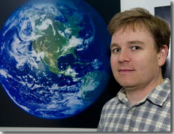
Photo of Robert Simmon in front of the "Blue Marble." |
NASA freely admits that their images are created with computer data; they are not photographs. When Data Visualizer and Designer, Robert Simmon, of NASA was asked, "What is the coolest thing you’ve ever done as part of your job at Goddard?" he answered:
"The last time anyone took a photograph from above low Earth orbit that showed an entire hemisphere (one side of a globe) was in 1972 during Apollo 17. NASA’s Earth Observing System (EOS) satellites were designed to give a check-up of Earth’s health. By 2002, we finally had enough data to make a snap shot of the entire Earth. So we did. The hard part was creating a flat map of the Earth’s surface with four months’ of satellite data. Reto Stockli, now at the Swiss Federal Office of Meteorology and Climatology, did much of this work. Then we wrapped the flat map around a ball. My part was integrating the surface, clouds, and oceans to match people’s expectations of how Earth looks from space. That ball became the famous Blue Marble. I was happy with it but had no idea how widespread it would become. We never thought it would become an icon. I certainly never thought that I would become “Mr. Blue Marble.” We have since updated the base maps by increasing the resolution and, for 2004, we made a series of monthly maps." (http://www.nasa.gov/centers/Elohimdard/about/people/RSimmon.html)
|
How was the "blue marble" image of Earth created? According to NASA, a "flat map" was created from alleged satellite data and then wrapped "around a ball." The image was then touched up to "match people's expectations of how Earth looks from space." |
Woe unto them that seek deep to hide their counsel from Yahuwah, and their works are in the dark, and they say, Who seeth us? and who knoweth us? Surely your turning of things upside down shall be esteemed as the potter's clay: for shall the work say of him that made it, He made me not? or shall the thing framed say of him that framed it, He had no understanding? (See Isaiah 29:15-16.)
Who do you trust? Yahuwah's prophets or the militarized secret society at NASA?
Thus saith the Yahuwah; Cursed be the man that trusteth in man, and maketh flesh his arm, and whose heart departeth from Yahuwah. For he shall be like the heath in the desert, and shall not see when good cometh; but shall inhabit the parched places in the wilderness, in a salt land and not inhabited.
Blessed is the man that trusteth in Yahuwah, and whose hope Yahuwah is. For he shall be as a tree planted by the waters, and that spreadeth out her roots by the river, and shall not see when heat cometh, but her leaf shall be green; and shall not be careful in the year of drought, neither shall cease from yielding fruit. (See Jeremiah 17:5-8.)